The Maritime Provinces – Newfoundland, New Brunswick, Prince Edward Island and Nova Scotia
The maritime provinces – Newfoundland, Prince Edward Island, New Brunswick and Nova Scotia – are generally regarded as a region that has chronic unemployment , and in one sense, is almost “the land that time forgot,” in that much of the economic development that has gone on in Canada moved west for various reasons. However, where there are issues like this, there may be opportunity for you. This article will explore those possible opportunities.
Newfoundland
If you consider this province, first attend the Newfoundland 101 class: the province may be pronounced by an emphasis on either the first or last syllable – never the middle one. Newfoundland joined Canada only in 1949, after some brief toying with the possibility of joining the US. One key economic item is the Hibernia oil field off the coast, which is a plus for economic stability, but generally Newfoundland is a place that has had chronic unemployment and people leave to find work. Jokes about “Newfies” are abound among Canadians – similar to the “Okies” stories told in the Great Depression. Excluding Labrador on the mainland, which we will not examine, NF is not called “the Rock” for nothing. While hunting, fishing and abundance of both fresh and salt water will not be a problem, generally the land is not fertile, nor will one be growing mangos, let alone corn, as this area of the world does not get hot even in summer.
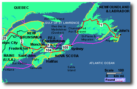
In a serious implosion, the positive is that one would be isolated from the “zombie hordes” in NF; however, this same isolation means that during more normal times, or even a the slow, grinding socialist malaise we are continuing down the path on under Obama , getting to and from the province is both expensive and time consuming. A flight from St. John’s (not to be confused with St. John, New Brunswick) to New York will set you back around $600 as of 2012. To get a sense of the geographic distance Newfoundland is from the other major North American population centres, one is actually a half hour to the east of the Atlantic time zone, which itself is, of course, one hour to the east of the Eastern time zone. You will not be close to anything.
The above being said, there may be entrepreneurial activities in Newfoundland, particularly in the ecotourism area. In a more grinding socialist downturn, the favoured cronies of the Obama administration will be getting richer, as has always been the case under every socialist regime that has ever existed (as George Orwell noted, in the socialist workers’ “paradise,” we’ll all be equal, only some of us will be “more equal” than the others.) Will they have money to spend on eco-tourism, and decide to visit there? Perhaps, if a very, very strong business plan is put together. Ecotourism is in its infancy around the world, and even less developed in Newfoundland. The key thing to remember about Newfoundland is the chronic, heavy unemployment, and distance from other major centres.
The capitol and main city (really, the only city), St. John’s, is located on the Avalon Peninsula in the far east of the province, with a population just under 200,000. In other words, the city is large enough to have some opportunity – particularly with a aforementioned Hibernia off-shore oil project – but not so large that one has to worry about urban issues encountered in, say, a Detroit or L.A. Weather will not be a plus, unfortunately. Described as a humid continental climate, the average January high in St. John’s is just under freezing, with the average high just under 70F in July. Temperature is moderated by the Gulf Stream, which isn’t too far offshore from St. John’s, and in fact the city has the mildest winters of any major Canadian city outside of British Columbia. On the downside, of all the cities in Canada, St. John’s is the foggiest (124 days/yr), snowiest (wet snow, usually, 141 in./yr), wettest (just under 60”/yr) windiest and cloudiest.
Memorial University, www.mun.ca, is a well-regarded university within the city, so you would not be leaping into an area where everyone wears coonskin hats and canoes to work. There are several other smaller cities on the island, while on the west side of the island, the Long Range with its fjords make for Norwegian like scenery – culminating on the northern tip of the island the only confirmed Viking settlement at L’Anse aux Meadows (http://www.pc.gc.ca/eng/lhn-nhs/nl/meadows/index.aspx). In sum, though the Hibernia oil fields offshore could provide employment for those in certain professions, and the cost of housing is cheap, the island is most likely not a viable alternative for most, in any scenario. In a zombie apocalypse, the island would be well protected from the hordes. Similarly, NF is too far out to be impacted by, say, an EMP burst from North Korea detonated over Kansas. However, one would have difficulty growing crops, and heating would be an issue if you were expecting to use solar. Similar to Alaska, in a serious apocalypse, one would be cut off from the mainland, and all that implies,both good and bad. Unfortunately, my summary is that the bad outweighs the good overall, and that Newfoundland be bypassed in your considerations.
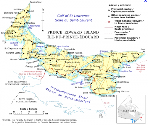
Working southeast , let’s next move to the tiny province of Prince Edward Island, whose capitol is Charlottetown in the map above. PEI is where Canada confederated as a country in 1867. The land is exceptionally fertile, flat, and one is literally never more than 20 -30 minutes from the ocean. If you would like to get a sense of the land, rent the critically acclaimed TV series Road to Avonlea, or the movie Anne of Green Gables. Not everything is filmed on the island, but much is, and might help to get a sense of the area. The capitol, Charlottetown, has a population of around 60,000, but feels larger as it serves as the hub for the whole island, population 150,000. Tourism is very heavy, particularly from Japan, which has developed a strong affinity for the Anne of Green Gable character over the years; more tourism is facilitated by the magnificent new Confederation Bridge, linking PEI to mainland Canada over Northumberland Strait (see http://www.confederationbridge.com/ or http://www.confederationbridge.com/about/confederation-bridge.html ) . Farming is definitely possible on the island, which is flat, fertile and serene. Winters are not overly cold, nor summers hot, due to the maritime influence found everywhere on the island. Business opportunity might revolve around tourism, fishing or Revenue Canada, the Canadian version of the IRS, which has a major office in Summerside – which might possibly allow for consulting opportunities. But, on the downside, PEI is the worse province for economic freedom. There are many pluses to PEI, but this must be carefully weighed against the lack ability to make a living and the intrusion of the state against your business freedom. My analysis is that PEI could be either an excellent choice for relocation in a serious collapse; however, in a more muted downturn, the lack of economic freedom makes the island a bad bet. If one thinks a more apocalyptic scenario is at hand, perhaps purchasing raw land and simply sitting on it for the present time might be one way to go.
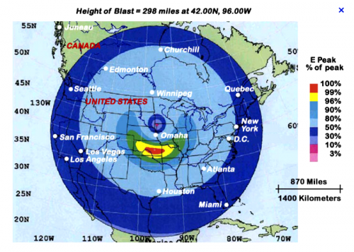
Long story short, the un-business friendly attitude of the province would argue against relocating here in a continued Obamanomics inspired malaise, although if tax and spend attitudes continue, the Revenue Canada site in Summerside might insulate one against a downturn. If, that is, one could stomach being part and parcel of the parasitic tax gatherer class. In an apocalyptic scenario, the island is off the beaten track, not near anything or anyone, and has substantial fishing and agriculture, and moderate winters. In a zombie apocalypse, with the un-tender ministrations of big government is gone, PEI would have a lot of positives, including the ability to get started purchasing land now for a fraction of the prices currently found elsewhere across the country. PEI, like Newfoundland, is on the periphery of an EMP blast’s effects (all the Maritime provinces are shown either not affected, or else marginally so, by an EMP nuke set off over the central part of the American continent. Of course, this assumes a single blast over the central part of the county, which may or may not be a reasonable assumption). In sum, my analysis is that PEI would not be good in a continued Obama-esque economic malaise, but in an apocalyptic, TEOTWAKI situation, might be an reasonable option. An added benefit is that land could be purchased right now for a reasonable price as “insurance.” www.dignam.com sells land all over the Maritimes, including PEI, and – as noted elsewhere in my articles – I have personally had a good experience with them.
Let’s move next to New Brunswick. The three major cities there, Moncton, St. John (not to be confused with St. John’s) and Fredericton, the capital, are all somewhere around the 150,000 range. Economically, they are mostly stagnant. While there are fertile agricultural areas is some spots, it is mostly rocky and forested – very similar to next door Maine. Key advantages to this province is that there has been no housing boom, there is easier access to the large cities down the road a number of hours, such as Boston or Montreal, yet the province is sparsely populated. However, in my opinion, this province does not have much going for it in a recession/depression, and in a zombie apocalypse, other than being remote, there is really not too much to recommend this area, other than low price of entry for land and homes. I do not believe this province warrants further attention – knowing, of course, that there are always special occasions, deals or locations that might make your choice different.
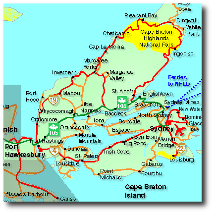
The final stop in our tour of Canada is Nova Scotia, a province I am going to heartily recommend. Let me first admit, I am biased, as I own land in this province on Cape Breton (at the far east in the picture above). The capitol, as well as the regional centre for all the Maritime provinces, is Halifax, population around 400,000 in the metro area. As the city is influenced by the Gulf Stream, the average high temperature in January is just below freezing, so temperatures are not unbearable at all. (Halifax monthly averages are found here:
http://www.weather.com/weather/wxclimatology/monthly/graph/CAXX0183; Canadian temperatures country wide are found here: http://gocanada.about.com/od/canadatravelplanner/tp/temperatures_canada.htm ). Halifax is a major port, was historically a major naval base, has reasonable cultural attractions, an international airport (e.g., IcelandAir flies out of there to Europe) and two universities. It is definitely a livable city – but without having to pay the price of larger cities you may be familiar with. Part of this is due to the fact that Halifax – the sister city of Boston – was much more significant 100 and more years ago. While population growth and development has migrated elsewhere, the city retains some of its old clout and attraction. For example, the two universities – St. Mary’s and Dalhousie – are still vibrant, strong schools well known throughout Canada.
As noted in my earlier articles, the Maritimes have been chronically depressed, and herein lies the opportunity, in that most people who needed, or wanted to leave, have already done so years ago (often moving to Toronto or Vancouver). In my opinion, there is little downside left. In a “soft” depression, Halifax would probably be no better, or worse, off than anywhere else. In a major apocalypse, it is a city of 400,000, which I think says it all – viz., that there are enough people to pose problems. Interestingly, in an EMP attack, examine the map below. Assuming a single blast over the centre of North America, Halifax is left untouched. Certainly, a single blast scenario exactly over the centre of the US may not be how things play out, but this map is nevertheless instructive.
Similarly, being on the periphery, Halifax is most likely not a target of any significance to anyone for any reason. There are bigger fish to fry (note that al Qaeda did try an attack on Toronto a few years ago, which was caught in time – I cannot imagine they would waste their time on Halifax!)
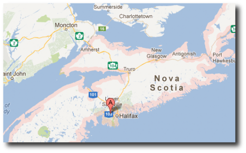
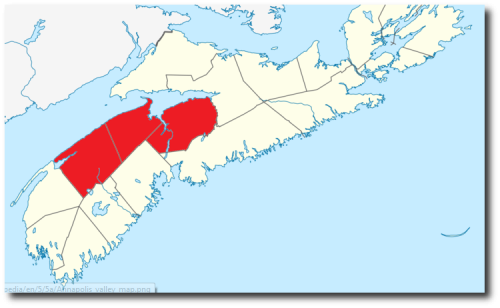
I think, however, there are better options in Nova Scotia. The very fertile Annapolis Valley north of Halifax (shown in red in the map below) has agricultural opportunities, reasonable land prices (remember, it seems like every third person has left for Toronto or Vancouver), and temperatures that are moderate by Canadian standards. The area north of Halifax would allow one access to the city via a modern four lane superhighway (the airport itself is 20 minutes north of Halifax), yet be able to have rural or semi-rural property that would allow one to be self-sustaining. In a soft downturn, business activity could be conducted in the city or by transiting in or out of the international airport; in a more apocalyptic scenario, the Annapolis valley has all that is needed to survive. And while Halifax is not small, neither will it have Los Angeles-style teaming hordes roaming the countryside.
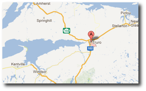
I am recommending the general region around the town of Truro, “The Hub of Nova Scotia,” on the Salmon River floodplain, with its population of 12,500. The city web site is
www.truro.ca. If needed, the Halifax airport is about 65 km (45 minutes) from the town, yet one is a world away from the hubbub of the city of Halifax. Long story short, Truro, or the land around it, could offer the best of both worlds – city access with rural/small town daily living – as well as allow one to hedge one’s bets against either a soft or hard coda to the economic music when the game of monetary musical chairs comes to an end.
One final area of recommendation – where I have chosen to purchase land – is near the town of St. Peters, on Cape Breton Island, which is at the far eastern end of Nova Scotia. As you drive eastward on the mainland of Nova Scotia, the land gets rockier, and less fertile, so large scale farming would be impractical for the most part (there are some smaller areas that would have reasonable land to till, of course, but this is not Saskatchewan). Cape Breton is moderately mountainous, with the centre of the island filled by Bras d’Or Lake. Significantly, Cape Breton has been chosen one of the top ten islands (#3, actually) by Travel and Leisure Magazine. http://www.travelandleisure.com/worldsbest/2011/islands , with Cape Breton Highlands National Park is a major visitor attraction. We have purchased land on Bras d’Or Lake, just north of the small town of St. Peters – which has a canal into the Atlantic for boats. Here was some of our reasoning: First, the island is stunningly beautiful.
Rocky and mountainous terrain (with some fertile patches are here and there) makes for incredible scenery, yet there is enough land to support personal gardens. As noted, land in the Maritime provinces is significantly cheaper than other booming areas of Canada. Ethnically, you may be surprised to learn that the highway road signs are in English and Gaelic (yes… Gaelic). This means you are in for some fine music.
The Micmac Indian tribes still have land in the area as well. People still seem to live closer to the land – a major plus if there is any type of TEOTWAKI situation. Perhaps most importantly, as this island was voted as one of the top ten in the world, the government is currently trying to complete a four lane superhighway to the Canso Causeway, which bridges the mainland to the island. We believe this will increase the value of the land significantly as it will increase tourism, while in an apocalyptic scenario, one is simply too far out from any population centres of any size (three hours to Halifax) for pillaging hordes to materialize. Moreover, sailing on the very large Bras d’Or Lake – which is slightly saline in that there are several fjords into the lake from the ocean on its eastern side – is extremely popular. In a more muted downturn, the lake will still attract the well-heeled sailing crowd out of the east coast, and will also attract wealthy vacationers. The lake is attractive enough that Alexander Graham Bell lived much of his time in a mansion just off the water. Being a tourism location, there are enough cultural activities to keep one engaged, and enough natural beauty to keep one serene. The town of Sydney (population 25,000, greater metro area approaching 50,000, with city web site at http://sydney.capebretonisland.com/) an hour or two from St Peter’s would be the main local hub.
This summarizes the Maritime provinces, and Canada as a whole. I hope someone, somewhere, is able to benefit from my broad background and knowledge of the country, from one coast to the other –all 4,187 miles (excluding Newfoundand).As noted at the start of this series, these are my opinions, and you would need to do your due diligence, should you decide to explore further. But as you can see… there’s a lot to explore.

